- 403-221-0915
- [email protected]
- CSE: TOC | FSE: TV3 | OTC: TCVNF
Gran Pilar Project
Sonora, Mexico
Au-Ag
Advanced Stage – Moving Towards Production
2,277.7 Ha
Epithermal Vein/ Breccia System
Tocvan Ventures
Resource Definition Drilling, Mine Applications, Exploration Discovery.
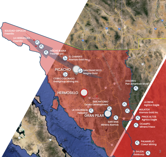
*5% of the project area Tocvan has Majority interest held in a 51/49 Joint Venture
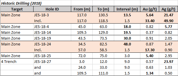
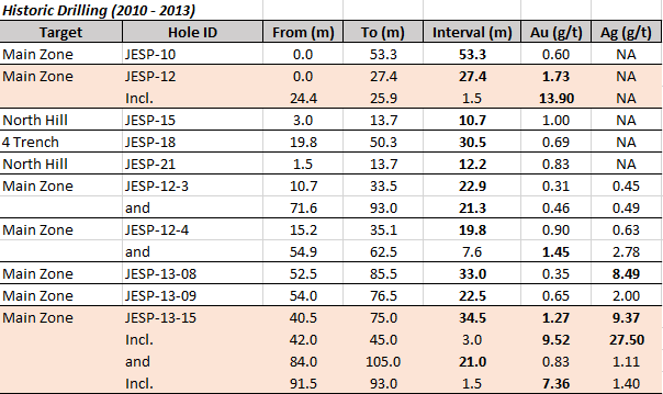
Pilar Drill Highlights:
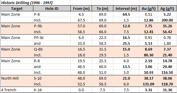
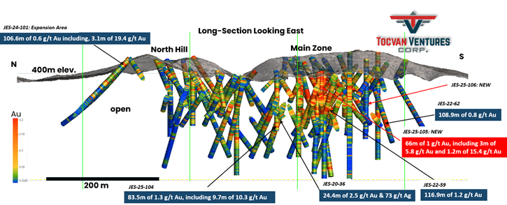
Pilar is located in an area of the western Sierra Madre underlain dominantly by Cretaceous-Paleocene Lower Complex intrusive and volcanic rocks. In addition, Mesozoic basement rocks as well as younger silicic alkaline volcanic rocks are locally mapped in the area.
Pilar is underlain by three rock types: andesite, granodiorite, and rhyolite. The andesite is mapped as part of the Lower Volcanic Complex of the Sierra Madre Occidental and is interpreted as being Cretaceous. The granodiorite is also mapped as being part of the Lower Volcanic magmatic event but is interpreted as Early Tertiary and therefore younger than the andesites. The contact zone of the granodiorite observed to the north and to the west side of the property is characterized by intense silicification and re-crystallization and is interpreted as a contact aureole/hornfels zone.
Three fault orientations have been mapped and interpreted on the property. The western contact between the volcanic rocks and the granodiorite is interpreted to be a north striking and steeply east dipping detachment structure which shallows under the volcanic rocks and places the volcanic rocks in the hanging wall and the granodiorite in the footwall. Within the hanginwall volcanic rocks there are 2 dominant fault orientations which include one fault set oriented at N40W which is similar to the orientation of the dykes and a second fault orientation at approximately right angles to the first with an orientation of N50E.
Gold and silver mineralization occurs within a zone of strong argillic alteration which locally contains overprinting strong silicification and weak sericitization. Veins on the property which consist of quartz and lesser carbonate and, in one case, gypsum. Sulphide mineralization is low to moderate in the gold and silver bearing zones being primarily pyrite and lesser pyrrhotite which weathers to bright red hematite. Better gold grades are interpreted to be associated with the most intense silicification and in other instances higher gold grades are associated with the occurrence of hematite on fracture surfaces. There are approximately 40 mineral workings on the Pilar property probably completed during the late 1800s to early 1900s period. (Summarized from Lavigne, 2016)
Diverse Terrain:
Rich Mineral Resources:
Copper Production:
Gold and Silver Mining:
Mining Infrastructure:
Mining Regulations:
Investment Opportunities:
Für weitere Informationen bitte geben Sie ihre E-mail Adresse hier ein